Old London Maps: Committed to granting those interested in history and genealogy, as well the simply curious, free access to scores of rare maps, views and images of London in the medieval, Stuart, Georgian, Regency and Victorian periods.

Articles on, information about, and views of Historical London
Over 500 pages of views and information - the story behind the maps

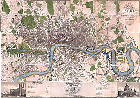
Christopher and John Greenwood's

Map of London ... from an Actual Survey made in the years 1824, 1825 and 1826
Published by the Proprietors, Greenwood, Pringle & Co., 13 Regent Street, Pall Mall, August 21, 1827


This is one of the more detailed and beautiful maps of London produced in the first half of the nineteenth century. For reproduction on the web it has been considerably enlarged for easier viewing. Some of the edges of the individual sections of our copy were a little faded and frayed, so just occasionally there are small sections of map missing or unclear, but they are only very small. The central sections of London are very dense and some of the engraving of the alleys is not as clear as it might have been. Again, the dilemma for us has been ease of downloading v. ease of viewing. If you find a link which doesn't work, can you please email us the page URL where you encountered the problem.

Please click within the key map for detailed views, or use the serch function below to find what you need.


Google
 
Web www.oldlondonmaps.com


Copyright © Sara Douglass Enterprises Pty Ltd 2006
No material may be reproduced without permission
Privacy Policy